Planning a trip to the north side of Mt. Everest in Tibet? Then don’t miss Tingri County (定日县)—known as the “Home of Mt. Everest.” This remote highland region isn’t just a final stop before reaching the Everest North Base Camp—it’s a soulful place where snow peaks, vast skies, and Tibetan culture meet.

I visited Tingri and found it breathtaking—both for its altitude and its quiet, raw beauty. If you’re drawn to prayer flags fluttering in the wind, mountain silhouettes at dawn, and a deep sense of peace, Tingri will stay with you forever.
1. Discovering Tingri County: Land of Giants
Tingri County sits in the heart of the Himalayas, nestled beneath towering peaks. It includes Shelkar Town (协格尔镇) and Gangkar Town (岗嘎镇), plus 19 surrounding townships. The county seat is in Shelkar Town.
The average elevation here is around 5,000 meters. Four mountains within Tingri rise above 8,000 meters—including the mighty Mt. Everest, the crown jewel of them all. Tingri isn’t just a stopover; it’s where the earth touches the sky.
1) Shelkar Town: Gateway to Everest’s North Face
Shelkar Town (协格尔镇), often called New Tingri, is the heart of Tingri County. It’s the administrative center and a popular base for travelers heading toward Mt. Everest.

At about 4,200 meters above sea level, the town lies right on the edge of the Himalayas. A river winds through its center, and ancient fortress ruins perch on the surrounding hills. I remember walking its quiet streets, looking up at the prayer flags fluttering over rooftops.
Shelkar is also the last proper town before Everest’s north base camp. Most travelers choose Baiba Village (白坝村), under Shelkar’s administration, as their starting point. It offers a gentler climb and more time to acclimatize if you stay or drive from Baiba to Mt. Everest.

National Highway 318 cuts right through Baiba Village, making it easily accessible. The village itself sits 7 km east of Shelkar Town‘s center. It’s also just 14 km from the highway fork that leads to Everest’s special mountain road.
I stayed in a simple hotel in Baiba Village. At night, the stars stretched across the sky, and Mt.Everest felt so close you could almost touch it.
2) Gangkar Town (Old Tingri): A Trekker’s Launch Pad
Gangkar Town (岗嘎镇), often called Old Tingri, once served as the seat of Tingri County. Although the government moved to Shegar Town in 1968, many locals—and even Google Maps—still refer to Gangkar as “Tingri.”

When I arrived, it felt quieter than Shelkar Town, but full of charm. National Highway 318 runs right through it, making Gangkar an important stop for overlanders heading from Zhangmu Fort or Shigatse.
Gangkar Town is especially popular with trekkers. It’s closer—only about 70 km—from here to Everest’s north base camp. The road is rougher than the route from Baiba, but more adventurous. I met a group of climbers here who hired a local yak transport team, which has been supporting expeditions for years.

Eleven small family-run inns offer basic but welcoming stays. I spent a night in one, sipping yak butter tea by a fire.
Most of all, the views stole my breath. From Gangkar, I saw Qomolangma (Everest), Cho Oyu, Lhotse, and Makalu all in one frame.
If you’re planning to trek to the base camp, start from Gangkar Town in Tingri County. It’s raw, rugged, and unforgettable.
2. Scenic Drive: From Tingri to the North Base of Mt. Everest (110km)
In late August, our group of 25 gathered in Baiba Village, nestled in Tingri County. A quiet thrill ran through us—we were heading to the legendary North Base Camp of Mt. Everest.
As we left Baiba in the early morning light, the sky slowly shifted from deep blue to a dusty rose. The journey ahead stretched 110 kilometers across some of the most rugged terrain in Tibet.

First, we stopped at Lugongong Police Checkpost. Everyone stepped off the bus, travel permits in hand. The process was detailed but smooth. Soon, we reboarded and veered off National Highway 318.
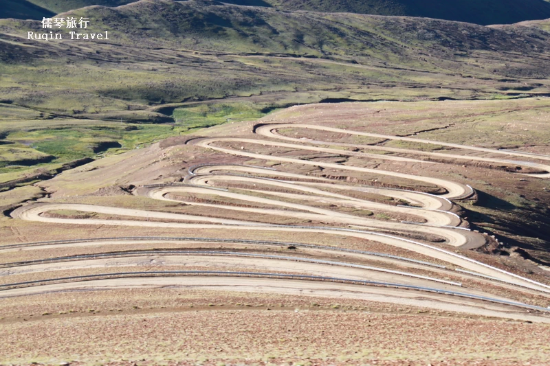
What followed was five to six hours of bone-rattling adventure. The road twisted and bounced over highland ridges and dry riverbeds. At times, we climbed steadily through switchbacks cut into the barren earth.
As we gained altitude, the landscape transformed. The vast Tibetan Plateau opened wide, dotted with hardy shrubs, prayer flags, and grazing yaks. We passed nomadic camps, where children waved and herds moved like shadows.
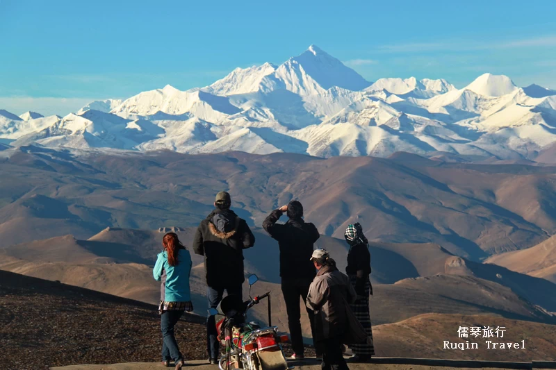
Our highest point came at Gyawula Pass (5,210 meters). The view stunned us into silence—Everest, framed by Lhotse, Cho Oyu, and Makalu, pierced the sky.

From there, we passed remote settlements, yaks, dzopkyos, and finally, Rongbuk Monastery. Standing in its shadow, with Everest ahead, felt deeply spiritual.

After tea in the tent village of Za-Rombuk, we switched to an eco-shuttle for the last 4 km.

The North Base Camp, at 5,200 meters, stood bare and bold. There were no climbers in August, just the roar of wind and the humbling presence of Everest itself.

We stood as tiny figures in the shadow of a giant. And yet, the entire journey—from the heart of Tingri County—felt like a path that led us exactly where we were meant to be.
3. Scenic Drive: From Tingri to Nyalam and Zhangmu Fort (253 km)
On a late August morning, we left Baiba Village in Tingri County just after 5:30 a.m. The sky was still deep blue as we set off from our hotel in Shelkar, known as New Tingri. Our goal? Zhangmu Fort, the historic border crossing into Nepal.
The road ahead was long—211 km to Nyalam Town, then another 42 km to Zhangmu Fort. But we were excited. This was the final stretch for some of our group who would soon cross into Nepal.

We followed the iconic National Highway 318, with Shishapangma Peak 希夏邦马峰 (8,012m) glowing in the sunrise to our left. The highway gradually climbed until we crossed Tong La Pass (通拉山口) at 5,126m and entered Nyalam County.

The drive from Tingri to Nyalam was one of the most scenic of our Tibet journey—snow peaks, deep gorges, waterfalls, and endless sky. We passed into the green valleys of Nyalam Town at 3,500 meters.

Next came a dramatic descent: from Nyalam to Zhangmu Town, we dropped over 1,000 meters in just 30 km. Waterfalls spilled from cliffs. Lush forests replaced dry plateau.

Zhangmu clung to the hillside, built along one zigzagging street. Trucks lined both sides, mostly from Nepal, loading and unloading goods. Traffic looked chaotic—but somehow it flowed.

We were nervous about delays, but drivers here moved like clockwork—no traffic lights, no police, just skill and rhythm.

From downtown, it was a tight, tricky 10 km drive to Zhangmu Port. Our driver, new to the route, handled it like a pro.

Finally, we reached the border. Nepal lay just across the Friendship Bridge, its houses visible on the slope below. We had reached the edge of Tibet—and the gateway to another world.
4. Tingri and Zhangmu Travel Tips: What I Learned on the Road
After completing the incredible journey from Tingri County to the border at Zhangmu, I gathered a few tips that made a big difference. If you’re planning a similar trip, here’s what I’d recommend:
1) Travel Smart in Tingri
First, smaller groups work better. Buses can get stuck on narrow mountain roads, but Land Cruisers or vans handle them like a dream.
Altitude is no joke. I saw a few fellow travelers struggle. So, bring bottled oxygen and altitude sickness meds just in case. Also, stay at least one night in Tingri before heading toward Everest or crossing to Nepal. It really helps your body adjust.
Pack water, snacks, sunscreen, sunglasses, and layers. The weather can change fast, especially in high-altitude regions like Tingri.
Don’t forget permits! You’ll need your Tibet Travel Permit and Alien Travel Permit, especially for Everest Base Camp.
The best time to visit? I’d say March, May, September, or October—the skies were clearer, and the roads were safer.
2) Surviving Zhangmu Border Chaos
Zhangmu Town is busy—really busy. The traffic is wild, so allow extra time for border procedures.
Some travelers stay overnight in Zhangmu, but Nyalam Town, just 30 km away, is quieter and higher up.
You’ll need your passport, China visa, and all permits ready. Keep them handy.
There’s no shuttle to Lhasa from Zhangmu, so plan to hitch a ride or find a return van or bus. Also, local taxis in town cost about RMB 10.
Most importantly, stay flexible. In places like Tingri County and Zhangmu, patience really is part of the adventure.
🌟Further Reading
Lhasa Travel Guide: Map, Highlights and Travel Tips
Shigatse: Map, Scenic Routes, Highlights and Travel Tips
How to Book Lhasa Attraction Tickets: All You Need to Know
How to Plan a Trip to Drak Yerpa in Lhasa – 9 Tips for your Visit
The Best Lhasa Tour Itinerary
Our Bus Driving Experience from Tingri to Mt. Everest Base Camp
How to Visit Mount Kailash in Tibet – Ruqin China Travel
How to Visit Mount Everest (Qomolangma) – Ruqin China Travel